Now I am in my sixth decade - My Sixties. Here I share my travels, observations and musings on life - its purpose and meaning.

Now I am in my sixth decade - My Sixties. Here I share my travels, observations and musings on life - its purpose and meaning.

Thursday, May 16, 2013

MST Hike 4 - Views and Wildflowers

It has been a few weeks since the last MST challenge hike due to a couple weeks off the trail and last week at the beach.  We planned a 10 mile hike from Pigeon Gap on the Blue Ridge Parkway to Forest Service Road 816 in the Black Balsam area.  There was over 3,000 feet of elevation gain going the direction we chose, but it was a beautiful day and a good workout was in order.


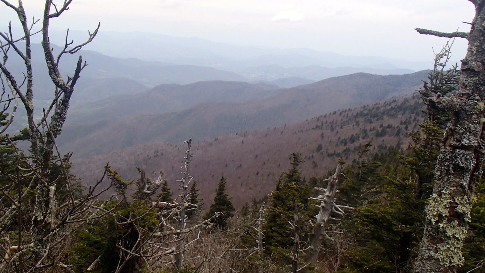
We climbed to over 5,000 feet at the start of the hike and I immediately noticed a season rewind. Although the temperature was warn, the picture above shows trees just budding. It was like we hiked from mid-May to early April.  As we hiked along the MST we could see the green valleys to the south, but to the north the higher elevations of the Black Balsams still showed little green.  We crossed the Blue Ridge Parkway twice.  At one crossing the view south gave a great view of Looking Glass Rock and the Davidson River Valley.


All along our hike we saw many wildflowers including painted trillium, wake robin, white violets, and bluets. Pink shell azaleas were in bloom as well.  A few pictures of the wildflowers we saw:


Both above: Painted Trillium

Pink shell azalea

Wake robin


Five miles into the hike we reached our lunch spot at Skinny Dip Falls.  These are very popular on warm summer days because they are easily reached by a connecting trail from an overlook at mile 417 on the Parkway.  There were only a few people there and we had a sunny spot on the rocks at the falls for lunch; and no I did not swim!

Skinny Dip Falls

Lower falls 
As we climbed during the afternoon there were more long range views to the south and east and views of Black Balsams and Tennent Mountain.  
View looking east

View toward Black Balsam
It was a beautiful warm day to be hiking in the woods.  The temperature was 77 degrees when we reached the car at the hike.  When I got to Old Fort it was 92.  Summer temperatures are here, but they can be escaped by going to higher elevations on the MST.


Monday, April 29, 2013

A Letter to Gov. McCrory


Dear Governor McCrory,
I am a retired teacher in McDowell County. I retired from teaching the sixth grade at Pleasant Gardens Elementary School after 31 years.  I currently serve as co-coordinator of the North Carolina Geographic Alliance, a position that allows me to stay in touch with teachers and spend some time volunteering in schools each year.

I totally disagree with your proposed budget that threatens to cut elementary teacher assistants. Teacher assistants are  such an integral part of early elementary classrooms.  They engage with students in reading, math and other subjects, assisting in instruction.  They perform clerical tasks and assist the classroom teacher with a myriad of other tasks. They  are the second set of eyes and ears in the classroom, helping students, reading with students, and being another adult figure for the students.

I strongly urge you to restore funding of teacher assistants in our early elementary classrooms.  Over the past several years, public education has been cut by state budgets. Proposals by you and our legislature only exacerbate the problem by further cuts and weakening the public schools.  In the past, North Carolina has been an excellent state for education with a very good climate for educators.  The gains of the past are eroding away. We are almost at the bottom in teacher pay, and now your budget will remove the asset of teacher assistants from the classroom. You will be putting many teacher assistants out of work.

North Carolina has had several "education governors" - governors who put public schools first and sought to improve K-12 education equitably across the state.  Your proposed budget and the policies and laws proposed by the current legislature will leave you as being remembered as the "non-education governor."

Thursday, April 25, 2013

The Black Mountain Crest Trail


We took a break from the MST 130 Challenge yesterday to hike the Black Mountain Crest trail, which as the name implies, follows the crest of the Black Mountains for 12 miles from Bolen's Creek to Mt.Mitchell.  One of the hikers in our group of four needed 3 peaks in the Blacks to complete the South Beyond 6,000 (SB6K) challenge.  This Carolina Mountain Club challenge involves summiting 40 peaks over 6,000 feet in elevation in Western NC and, in the Smokies, in Tennessee.  12 of these peaks lie in the Black Mountain, from Celo Knob in the north to Blackstock Knob in the south.  

We began hiking a little after 8:00 am off Bolen's Creek Road. The trail ascends 3,000 feet in about 4 miles, so our day started with a sustained climb.  It is evident when you reach the crest of the Blacks, because you can see virtually all the peaks you will be crossing as you hike south toward Mt. Mitchell.  The picture  above  shows the view looking south.  All the peaks shown are over 6.000 feet.  

Gibbs Mountain was the first of the three peaks needed to complete the SB6K challenge, and it requires an off-trail bushwhack.  We took off through the briars and trees, working our way up the short distance to the summit.  Several rocks are at the top, and the high point did not provide much of a view.  We worked our way back down and hiked south toward lunch and the next peak, Winter Star Mountain.  

The trail up WInter Star is a series of steep climbs often very rocky.  In some places you wonder where the trail went, then you realize that it is up and over the rocks ahead of you.  Look for the trail in this picture. It is directly in front at the center of the picture.


The main features of the Black Mountain Crest trail are lots of ascending and descending, lots of rocks, and lots of roots.  There is about the same amount of climbing along the crest as there was on the initial 3,000 foot climb at the beginning of the hike.  At the end of the hike we had a total ascent of over 5,700 feet.  The trail also provides expansive views east of the crest toward the South Toe River valley, and west of the crest toward the North Toe River valley.  Some areas we open and there were many interesting rocks.  Due to the extreme winters there are lots of blow downs, although the trail was mostly clear of them.  Environmental conditions and insects have harmed the older trees, as seen by the ghostly skeletons still standing.


The weather was sunny to cloudy during most of the day.  The temperature at 6.000 feet was comfortable, but we know the forecast was for rain later in the day.  As we approached Big Tom and Mt. Craig over the last 2 miles of the hike the wind and rain started.  Donning rain gear we continued on.  Everything was socked in by clouds, so we lost any views we enjoyed earlier in the day.  

After 8 hours of a steep and hard 12 miles we reached the car at the Mt. Mitchell parking lot.  All in all a good day on the Crest. 

A few more pictures from the hike.

View to the east

Fern rock garden

Looking southeast 


Thursday, April 18, 2013

MST Hike 3

West of Asheville the Blue Ridge Parkway climbs from an elevation on 2100 feet at the French Broad River overlook to nearly 5000 feet at the Pisgah Inn.  The Mountains to the Sea Trail (MST) follows the Parkway in both miles and elevation.  Our most recent hike took us from Stony Bald overlook - elevation 3750 - to Pigeon Gap - elevation 4520.  Over the 13.8 miles we climbed over 3000 feet.  Our highest point on the trail was Little Pisgah Mountain at 5285 feet.


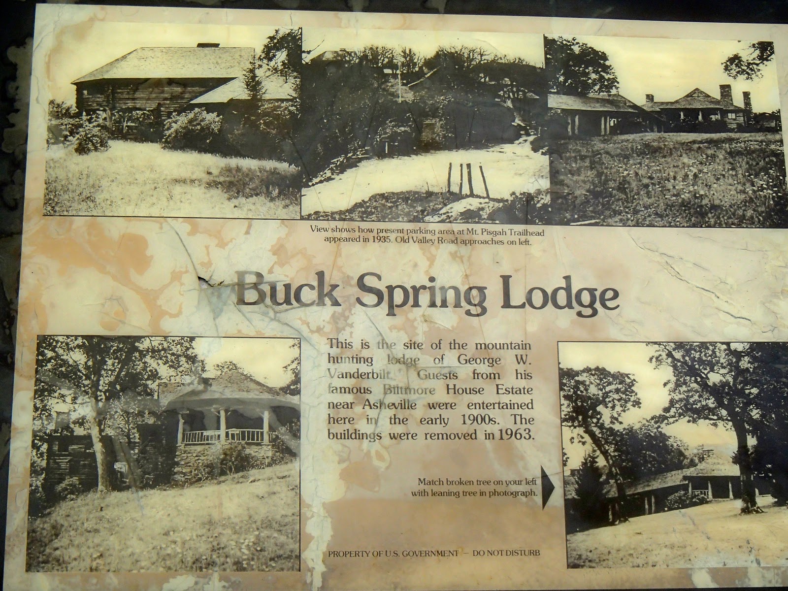
The first half of the hike took us over Little Pisgah to the Buck Springs Lodge site and the Pisgah Inn.  Buck Springs Lodge was a hunting lodge built by George Vanderbilt in 1896 (one year after the Biltmore House was opened).  Lying some 20 miles west of the Biltmore House, it was reached by the Shut-in Trail that connected the estate to the lodge.  Today, the MST follows part of this historic trail, and the 18 mile section is still called the Shut-in Trail.

There is a sign at the site of the Buck Springs Lodge, but the buildings are long gone.  The stonework of a root cellar remains.  The Pisgah Inn has an interpretive trail that connects the lodge site with the inn.  The Pisgah Inn is a popular restaurant and motel on the Parkway near Mt. Pisgah.  Most people recognize Mt. Pisgah by the WLOS TV transmitting tower on the summit.  A spur trail off the MST reaches the summit.

After the Pisgah Inn the MST follows the Buck Springs trail to Highway 276 and Pigeon Gap.  This trail has over a dozen water crossings as it winds in and out of several mountain coves.  The sound of rushing water is heard frequently; and the afternoon we hiked we also had a couple hours of rain.  It was the most scenic part of the hike, and despite the rain and occasional lightning and thunder, an enjoyable six mile ramble.  The last part of the hike was a 500 climb to Pigeon Gap and our car.

Some views along the Buck Springs TRail (MST)


With this section of the MST we have completed 35 of the 130 miles of the MST Challenge.  As we push farther west, our drive time to the trailhead will increase, but the views and the scenery is well worth the drive.

Next week wil be a break from the MST.  A small group will be hiking the Black Mountain Crest trail from Bowlens Creek to Mt. Mitchell.  It is a challenging hike that is lovingly referred to as the "death march."

Thursday, April 11, 2013

Two MST Hikes in Two Days

Last Sunday and Monday found me on two different sections of the Mountains to Sea Trail in the North Carolina mountains.  On Sunday, April 7 the CMC hike scheduled a hike from Lake James (actually the end of Wolf Pit Road near the lake) to Table Rock on the east rim of the Linville Gorge.  I have been to Table Rock from the parking area and I have hiked from Wolf Pit Road trailhead to Shortoff Mountain, but I have never hiked the in-between section.  This hike would be my opportunity.
So, early Sunday I met a group of 13 hikers who showed up for a strenuous hike.  After a mile climb up to Shortoff Mountain we were treated to views of the Linville Gorge and far below the Linville River.  Shortoff has a very steep cliff that drops several hundred feet to the gorge below.  The MST  winds along the top of Shortoff through an area that has been burned in the past few years.

After a few miles Table Rock and the ridge called The Chimneys came into view.


Table Rock still looked a long way off, but the day was warm and the trail was good.  We hiked on and gradually dropped in elevation to Chimney Gap.  From that gap to the ridge the trail climbed almost 1,000 feet in about a mile.  Steep going, but we gained the ridge and hiked along the most distinctive feature of the day - The Chimneys, seen in the center of the picture below.


We hiked along and under massive rock formations that are typical of the Linville Gorge.  We reached the Table Rock parking lot and picnic area at 1:00 and then climbed up to the top of Table Rock for lunch with a view.  The distance was 7.7 miles from our start.  After a leisurely lunch and taking n the views we began the hike back.  We reached our cars at the Wolf Pit trailhead a 6:30.  Total distance was 15.3 miles with a total climb of 4,176 feet.  This was a rugged section of the MST that lies outside the Carolina Mountain Club MST 130 Challenge.

The next day a small group of CMC hikers did hike a section for the challenge.  This section followed the MST from Stony Bald Overlook to the French Broad River Overlook along the Blue Ridge Parkway west of Asheville.  It was another warm spring day that had us hiking in short sleeves before lunch.  We had a steep climb up Ferrin Knob and a few other moderate climbs during the day.  The MST wound through several coves that has rhododendron and laurel tunnels that reminded us that this section of the MST is part of the Shut-In Trail that linked the Biltmore Estate with Buck Spring Hunting Lodge located near Mt. Pisgah.  

We saw our first wildflowers on Monday; bloodroot carpeted several areas along the trail.


By 3:30 we had reached the cars at the French Broad Overlook at the end of an 11.7 mile hike.  Our next MST hike will take us a little farther west to the Pisgah Inn and beyond to the Highway 276 crossing of the Blue Ridge Parkway.

Thursday, April 4, 2013

The Start of Two New Challenges

The Carolina Mountain Club in Asheville is celebrating its 90th  year with two new challenges.  The club maintains 130 miles of the Mountains to Sea Trail (MST) and 93 miles for the Appalachian Trail (AT).  The "90 in 90 AT Challenge" and the "MST 130 Challenge" require one to hike these sections during the 2013 calendar year.  Over the past several years, I have hiked most of the MST trail mile and some of the AT miles, but this challenge requires they be hiked in 2013.

These challenges are not so much a competition, but a personal challenge to hike almost 200 miles of trails in Western North Carolina.  They will require some planing and the logistics of car shuttles, particularly for the MST challenge.

My friend Rich and I are planning on completing both challenges, and we started the MST challenge with an 11 mile hike on the MST through the "Asheville Corridor."  For those who don't know, much of the MST follows the Blue Ridge Parkway through the Asheville area.  The section of the Parkway from the Folk Art Center to Highway 191 (Brevard Rd.) is heavily used by commuters looking for an alternative to highway driving.   This area is also within sight of houses and other developed areas.

We hiked from the Blue Ridge Parkway Destination Center (milepost 384) to the French Broad River Overlook (milepost 393).  This section of the MST is not particularly steep as it winds its way across wooded land.  Probably the most notable thing about this section is that the MST uses the Parkway bridges over major roads.  Highways 74-A, 25-A, a railroad, Highway 25, and I-26 are al crossed by walking on the Parkway bridges over them.  At the end of the hike we crossed the French Broad River on the Parkway bridge near the overlook and the access to Hwy 191 and Brevard Road.


It was a clear day with temperatures in the low 60s.  We completed the 11 miles in less than 5 hours.  Now that we have our first MST section done, we are committed to completing the challenge.  Next up: the 10 miles from the Destination Center north to Ox Creek Road/Bull Gap.  This is another Asheville section of the MST.

The French Broad River from the Parkway Bridge
All photos by Rich Sampson

For the AT challenge, we are planning to do them in three three-day backpacking trips.  More on that later.

Thursday, November 22, 2012

Thanksgiving

Thanksgiving Day is a day set apart for giving thanks.  It is a day steeped in tradition and goes back to the roots of our country.  Who doesn't remember Thanksgiving pageants with Pilgrims and Indians in elementary school?  It is a day for family sharing a meal and spending time together. Most of all it is a day to pause and reflect; to count our blessings.

Unfortunately, Thanksgiving Day is being overshadowed by Christmas - not the Christmas that celebrates "the Word made flesh" but the commercial season of Christmas.  Stores and ads seem to jump from Halloween right to Christmas. Black Friday is now becoming Black Thursday as more and more stores have pushed openings to Thanksgiving.  Sad to see Thanksgiving become just another day of buying and selling in the marketplace.  But we can make choices, and I will choose to honor Thanksgiving by giving thanks.

I am blessed with family, friends, and a church family who are always there and are a constant presence in my life.  I live in a country that does not dictate religious beliefs; I am free to worship and express my beliefs. I am thankful for health and well-being and the ability to experience God's creation.  Most of all, I am thankful for God's mercy and grace through Jesus Christ.  What a blessed assurance!

This Thanksgiving is touched with sadness.  Our church family lost one of its saints this week.  Frank Miller passed on to new life with The Lord.  He will be missed by many, but his suffering is no more. Frank was a gentle man who always looked for ways to help others.  He was a true friend and teacher, and in many ways a father to me since my Dad died in 2004.  I learned a lot about gardening and carpentry from Frank, but most of all I learned from his example.  Frank had a quiet way about him, a steadfast faith, and a generous heart.  If you drive around McDowell County and see a ramp at a home, it is a good bet that Frank and a crew of volunteers built it.   Frank Miller will be missed greatly by his devoted family, his church family, and many friends. We can honor his memory by living thankful lives, loving our neighbors, and practicing generous justice; just as Frank did.

Give a prayer of thanks this day for blessings received.

Happy Thanksgiving!